Fayl:AYool_topography_15min.png
From Wikipedia, the free encyclopedia
Size of this preview: 800 × 561 pixels. Başqa çözüm: 320 × 224 pixels | 640 × 448 pixels | 1.024 × 717 pixels | 1.280 × 897 pixels | 1.617 × 1.133 pixels.
Kerçek fayl (1.617 × 1.133 piksel, fayl büyükligi: 1,15 MB, MIME çeşiti: image/png)
This file is from Wikimedia Commons and may be used by other projects. The description on its file description page there is shown below.
Faylğa ait qısqa tarif
| TasvirAYool topography 15min.png |
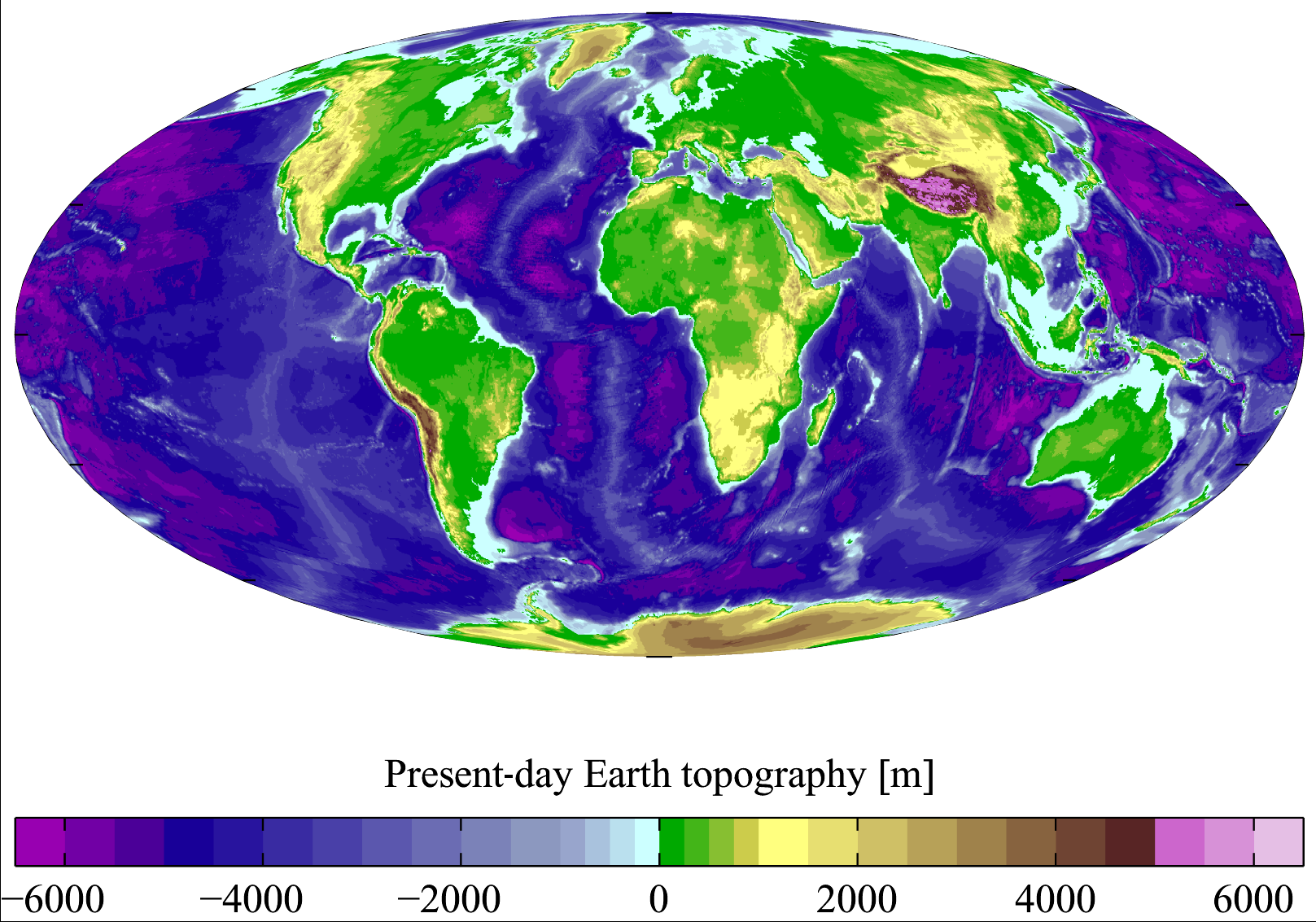
English: Present-day Earth topography and bathymetry at 15-minute horizontal resolution. Derived from the National Geophysical Data Center's TerrainBase Digital Terrain Model (v1.0). The original dataset is at 5-minute resolution, and this has been averaged down to 15-minute resolution. It is plotted here using a Mollweide projection (using MATLAB and the M_Map package). |
| Tarih | |
| Menba | English Wikipedia |
| Yaratıcı | Plumbago |
| Other versions |
Derivative works of this file: |
Litsenziyalama
I, the copyright holder of this work, hereby publish it under the following licenses:

|
Permission is granted to copy, distribute and/or modify this document under the terms of the GNU Free Documentation License, Version 1.2 or any later version published by the Free Software Foundation; with no Invariant Sections, no Front-Cover Texts, and no Back-Cover Texts. A copy of the license is included in the section entitled GNU Free Documentation License.http://www.gnu.org/copyleft/fdl.htmlGFDLGNU Free Documentation Licensetruetrue |
| This file is licensed under the Creative Commons Attribution-Share Alike 3.0 Unported license. | ||
| ||
| This licensing tag was added to this file as part of the GFDL licensing update.http://creativecommons.org/licenses/by-sa/3.0/CC BY-SA 3.0Creative Commons Attribution-Share Alike 3.0truetrue |
This file is licensed under the Creative Commons Attribution 2.5 Generic license.
- Azatsıñız:
- paylaşuv – qopyaluv, dağıtuv ve iletüv
- remiks etüv – uyğunlaştıruv
- Bu şartlar astında:
- attribution – You must give appropriate credit, provide a link to the license, and indicate if changes were made. You may do so in any reasonable manner, but not in any way that suggests the licensor endorses you or your use.
İstedigiñiz lisansnı seçebilirsiñiz.
Captions
Add a one-line explanation of what this file represents
Summer Earth 2023 Log
Items portrayed in this file
depicts English
copyright status English
copyrighted English
7 mart 2007
media type English
image/png
checksum English
713475ce2ce7f77875407450fddbcb7f68925a1a
data size English
1.207.885 byte
height English
1.133 pixel
width English
1.617 pixel
Faylnıñ keçmişi
Faylnıñ kerekli anki alını körmek içün tarihqa/saatqa basıñız.
| Tarih ve saat | Kiçik resim | En × boy | Qullanıcı | İzaat | |
|---|---|---|---|---|---|
| şimdiki | 18:18, 2011 s. noyabrniñ 10 | | 1.617 × 1.133 (1,15 MB) | JorisvS | added missing hyphen |
| 02:52, 2008 s. yanvarniñ 27 |  | 1.617 × 1.133 (1,05 MB) | Sswelm | == Summary == Present day Earth altimetry and bathymetry at 15 minute horizontal resolution. Derived from the National Geophysical Data Center's [http://www.ngdc.noaa.gov/seg/fliers/se-1104.shtml TerrainBase Digi |
Fayl qullanıluvı
Bu saife qullana bu fayldı:
Umumiy fayl qullanıluvı
Bu vikilerde bu fayldı qullana:
- an.wikipedia.org qullanım
- ast.wikipedia.org qullanım
- ba.wikipedia.org qullanım
- be.wikipedia.org qullanım
- bg.wikipedia.org qullanım
- bh.wikipedia.org qullanım
- bn.wikipedia.org qullanım
- bo.wikipedia.org qullanım
- bs.wikipedia.org qullanım
- ca.wikipedia.org qullanım
- ceb.wikipedia.org qullanım
- cs.wikipedia.org qullanım
- da.wikipedia.org qullanım
- el.wikipedia.org qullanım
- en.wikipedia.org qullanım
- Earth
- Physical oceanography
- Bathymetric chart
- Terrain
- Bathymetry
- User:Plumbago/Images
- Geology of solar terrestrial planets
- User:Plumbago/Science
- User:Mitternacht90/EarthandSpace
- Talk:Continent/Archive 5
- User:AvionArchon/sandbox
- User:Darth Tacker/TWA/Earth
- User:CheChe/Spoken Script
- User:Zanygenius/TWA/Earth
- User:Zanygenius/TWA/Earth/2
- User:GeoVenturing/FOCCPAC
- User:Google7722/TWA/Earth
- User:XanUltra
- Portal:World
- User:FreshYoMama/TWA/Earth
- User:FreshYoMama/TWA/Earth/2
- en.wikiversity.org qullanım
- es.wikipedia.org qullanım
- eu.wikipedia.org qullanım
- fa.wikipedia.org qullanım
- fr.wikipedia.org qullanım
View more global usage of this file.
Resim detalleri
Faylda (adetince raqamlı kamera ve skanerlernen qoşulğan) ilâve malümatı bar. Eger bu fayl yaratılğandan soñ deñiştirilse edi, belki de bazı parametrler eskirdi.
| Horizontal resolution | 37,79 dpc |
|---|---|
| Vertical resolution | 37,79 dpc |
| File change date and time | 10:08, 2007 s. martnıñ 7 |