File:A_new_map_of_North_America_-_with_the_British,_French,_Spanish,_Dutch_&_Danish_dominions_on_that_great_continent,_and_the_West_India_Islands,_according_to_the_definitive_treaty_concluded_at_Paris_10th_NYPL434522.tiff
From Wikipedia, the free encyclopedia

Size of this JPG preview of this TIF file: 800 × 525 pixels. Other resolutions: 320 × 210 pixels | 640 × 420 pixels | 1,024 × 672 pixels | 1,280 × 840 pixels | 2,560 × 1,680 pixels | 5,803 × 3,808 pixels.
Original file (5,803 × 3,808 pixels, file size: 63.23 MB, MIME type: image/tiff)
| This is a file from the Wikimedia Commons. Information from its description page there is shown below. Commons is a freely licensed media file repository. You can help. |
Summary
| DescriptionA new map of North America - with the British, French, Spanish, Dutch & Danish dominions on that great continent, and the West India Islands, according to the definitive treaty concluded at Paris 10th NYPL434522.tiff | A new map of North America : with the British, French, Spanish, Dutch & Danish dominions on that great continent, and the West India Islands, according to the definitive treaty concluded at Paris 10th February 1763 / with great improvements from the Sieurs d'Anville & Robert. | |||||||||||||||||||||||
| Notes InfoField | Includes historical notes, treaty extracts, prevailing wind directions, 10 insets of harbors, and a table showing that "North America is divided into the continent & the islands" according to geography and politics. Note 2.) Lawrence H. Slaughter Collection ; 735. Note 3.) National Endowment for the Humanities Grant for Access to Early Maps of the Middle Atlantic Seaboard. Note 4.) Relief shown pictorially. | |||||||||||||||||||||||
| Physical description InfoField | 1 map : hand col. ; 57 x 95 cm. | |||||||||||||||||||||||
| Catalog Call Number InfoField | Map Div. 97-6410 [LHS 735] | |||||||||||||||||||||||
| Date |
circa 1763 date QS:P,+1763-00-00T00:00:00Z/9,P1480,Q5727902 |
|||||||||||||||||||||||
| Source |
http://digitalgallery.nypl.org/nypldigital/dgkeysearchdetail.cfm?imageID=434522
institution QS:P195,Q219555 |
|||||||||||||||||||||||
| Author | Sayer, Robert, 1725-1794 -- Cartographer ;Anville, Jean Baptiste Bourguignon d', 1697-1782 -- CartographerRobert de Vaugondy, Didier, 1723-1786 -- Cartographer | |||||||||||||||||||||||
| Permission (Reusing this file) |
From The Lionel Pincus & Princess Firyal Map Division. Released on a CC0 license.[1] | |||||||||||||||||||||||
| Digital ID InfoField | 434522 | |||||||||||||||||||||||
| Location InfoField | Stephen A. Schwarzman Building / The Lionel Pincus and Princess Firyal Map Division | |||||||||||||||||||||||
| NYPL digital item published InfoField | 2-3-2004; updated 3-25-2011 | |||||||||||||||||||||||

Licensing
| This file is made available under the Creative Commons CC0 1.0 Universal Public Domain Dedication. | |
| The person who associated a work with this deed has dedicated the work to the public domain by waiving all of their rights to the work worldwide under copyright law, including all related and neighboring rights, to the extent allowed by law. You can copy, modify, distribute and perform the work, even for commercial purposes, all without asking permission.
http://creativecommons.org/publicdomain/zero/1.0/deed.enCC0Creative Commons Zero, Public Domain Dedicationfalsefalse |
The making of this file was supported by Wikimedia UK.
To see other files made with the support of Wikimedia UK, please see the category Supported by Wikimedia UK. বাংলা | Cymraeg | Deutsch | English | italiano | Nederlands | português | македонски | русский | slovenščina | +/− |
Captions
Add a one-line explanation of what this file represents
Items portrayed in this file
depicts
image/tiff
dfbfea1ef3b46b1ab8919729210449f897a2cbe6
66,298,900 byte
3,808 pixel
5,803 pixel
File history
Click on a date/time to view the file as it appeared at that time.
| Date/Time | Thumbnail | Dimensions | User | Comment | |
|---|---|---|---|---|---|
| current | 09:31, 19 January 2023 | 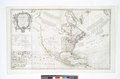 | 5,803 × 3,808 (63.23 MB) | Sebastian Wallroth | rotated 180° using CropTool with lossless mode. |
| 09:31, 19 January 2023 |  | 5,803 × 3,808 (63.23 MB) | Sebastian Wallroth | rotated 90° using CropTool with lossless mode. | |
| 02:38, 8 April 2014 |  | 3,808 × 5,803 (63.23 MB) | Fæ | =={{int:filedesc}}== {{NYPL_map |digital_id = 434522 |creators = Sayer, Robert, 1725-1794 -- Cartographer ;Anville, Jean Baptiste Bourguignon d', 1697-1782 -- Cartographer |record_id = 253142 |catalog_call_number = Map Div. 97-6410 [LHS 735] |item_phy... |
File usage
No pages on the English Wikipedia use this file (pages on other projects are not listed).
Metadata
This file contains additional information, probably added from the digital camera or scanner used to create or digitize it.
If the file has been modified from its original state, some details may not fully reflect the modified file.
| Width | 5,803 px |
|---|---|
| Height | 3,808 px |
| Bits per component |
|
| Compression scheme | Uncompressed |
| Pixel composition | RGB |
| Image data location | 8 |
| Orientation | Normal |
| Number of components | 3 |
| Number of rows per strip | 3,808 |
| Bytes per compressed strip | 66,293,472 |
| Horizontal resolution | 300 dpi |
| Vertical resolution | 300 dpi |
| Data arrangement | chunky format |
| White point chromaticity |
|
| Chromaticities of primarities |
|