File:Champlainmap.png
From Wikipedia, the free encyclopedia
No higher resolution available.
Champlainmap.png (465 × 470 pixels, file size: 36 KB, MIME type: image/png)
| This is a file from the Wikimedia Commons. Information from its description page there is shown below. Commons is a freely licensed media file repository. You can help. |
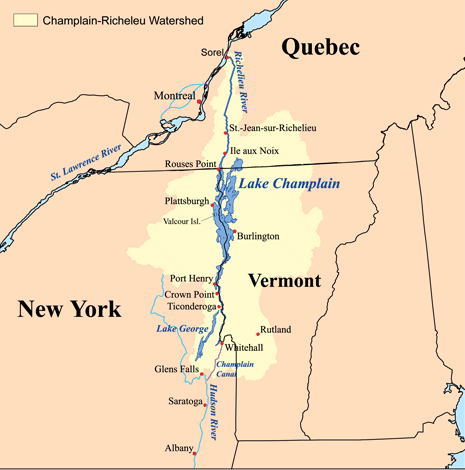
Summary
| DescriptionChamplainmap.png | This is a map showing the Lake Champlain - Richelieu River watershed. I made using USGS, Census Bureau, and Digital Chart of the World data. |
| Date | |
| Source | Own work |
| Author | Kmusser |
| Other versions |
Derivative works of this file: |
Licensing
I, the copyright holder of this work, hereby publish it under the following license:
This file is licensed under the Creative Commons Attribution-Share Alike 2.5 Generic license.
- You are free:
- to share – to copy, distribute and transmit the work
- to remix – to adapt the work
- Under the following conditions:
- attribution – You must give appropriate credit, provide a link to the license, and indicate if changes were made. You may do so in any reasonable manner, but not in any way that suggests the licensor endorses you or your use.
- share alike – If you remix, transform, or build upon the material, you must distribute your contributions under the same or compatible license as the original.

|
File:Champlainmap.svg is a vector version of this file. It should be used in place of this PNG file when not inferior.
File:Champlainmap.png → File:Champlainmap.svg
For more information, see Help:SVG.
|
 |
Captions
Add a one-line explanation of what this file represents
Items portrayed in this file
depicts
26 July 2006
image/png
91614ffe82f6c0e6f95213ee23e501bf795d9dc3
36,608 byte
470 pixel
465 pixel
File history
Click on a date/time to view the file as it appeared at that time.
| Date/Time | Thumbnail | Dimensions | User | Comment | |
|---|---|---|---|---|---|
| current | 23:38, 28 March 2011 | | 465 × 470 (36 KB) | Gilbertus | retrait du cadre |
| 17:29, 26 July 2006 |  | 500 × 500 (34 KB) | Kmusser | ||
| 17:02, 26 July 2006 |  | 500 × 500 (34 KB) | Kmusser | This is a map showing the Lake Champlain - Richelieu River watershed. I made using USGS, Census Bureau, and [[:en:Digital Chart of |
File usage
The following pages on the English Wikipedia use this file (pages on other projects are not listed):
Global file usage
The following other wikis use this file:
- Usage on af.wikipedia.org
- Usage on be.wikipedia.org
- Usage on bg.wikipedia.org
- Usage on cs.wikipedia.org
- Usage on de.wikipedia.org
- Usage on eo.wikipedia.org
- Usage on es.wikipedia.org
- Usage on fi.wikipedia.org
- Usage on it.wikipedia.org
- Usage on ja.wikipedia.org
- Usage on nl.wikipedia.org
- Usage on no.wikipedia.org
- Usage on pl.wikipedia.org
- Usage on sk.wikipedia.org
- Usage on sv.wikipedia.org
- Usage on www.wikidata.org
- Usage on zh.wikipedia.org
Retrieved from "https://en.wikipedia.org/wiki/File:Champlainmap.png"