File:Karte_Alpenrhein.png
From Wikipedia, the free encyclopedia
Size of this preview: 359 × 599 pixels. Other resolutions: 144 × 240 pixels | 288 × 480 pixels | 708 × 1,181 pixels.
Original file (708 × 1,181 pixels, file size: 399 KB, MIME type: image/png)
| This is a file from the Wikimedia Commons. Information from its description page there is shown below. Commons is a freely licensed media file repository. You can help. |
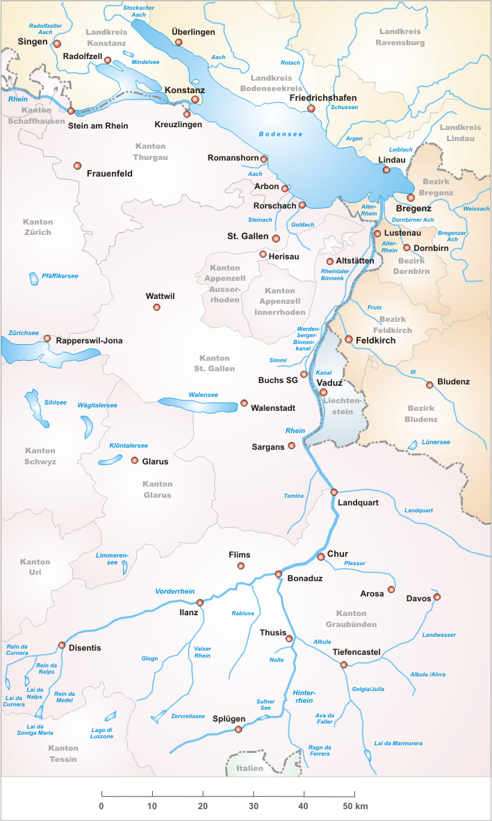
- Description: Alpenrhein / Vorderrhein / Hinterrhein

|
This map image could be re-created using vector graphics as an SVG file. This has several advantages; see Commons:Media for cleanup for more information. If an SVG form of this image is available, please upload it and afterwards replace this template with
{{vector version available|new image name}}.
It is recommended to name the SVG file “Karte Alpenrhein.svg”—then the template Vector version available (or Vva) does not need the new image name parameter. |
- Designer: Tschubby
- Licence:

|
Permission is granted to copy, distribute and/or modify this document under the terms of the GNU Free Documentation License, Version 1.2 or any later version published by the Free Software Foundation; with no Invariant Sections, no Front-Cover Texts, and no Back-Cover Texts. A copy of the license is included in the section entitled GNU Free Documentation License.http://www.gnu.org/copyleft/fdl.htmlGFDLGNU Free Documentation Licensetruetrue |
| This file is licensed under the Creative Commons Attribution-Share Alike 3.0 Unported license. | ||
| ||
| This licensing tag was added to this file as part of the GFDL licensing update.http://creativecommons.org/licenses/by-sa/3.0/CC BY-SA 3.0Creative Commons Attribution-Share Alike 3.0truetrue |
Captions
Add a one-line explanation of what this file represents
Items portrayed in this file
depicts
image/png
File history
Click on a date/time to view the file as it appeared at that time.
| Date/Time | Thumbnail | Dimensions | User | Comment | |
|---|---|---|---|---|---|
| current | 22:02, 18 December 2006 | | 708 × 1,181 (399 KB) | Tschubby | |
| 22:04, 24 May 2006 |  | 885 × 1,477 (526 KB) | Tschubby | ||
| 22:01, 24 May 2006 |  | 885 × 1,477 (526 KB) | Tschubby | *Description: Alpen-, Vorder und Hinterrhein *Date: 25.05.2006 *Author: Tschubby *Licence: {{GFDL}} Category:Maps of Swiss Rivers¦Alpenrhein | |
| 21:59, 24 May 2006 |  | 885 × 1,477 (526 KB) | Tschubby | *Description: Alpenrhein / Vorderrhein / Hinterrhein *Designer: Tschubby *Licence: {{GFDL}} Alpenrhein |
File usage
The following pages on the English Wikipedia use this file (pages on other projects are not listed):
Global file usage
The following other wikis use this file:
- Usage on als.wikipedia.org
- Usage on be.wikipedia.org
- Usage on bg.wikipedia.org
- Usage on da.wikipedia.org
- Usage on de.wikipedia.org
- Usage on de.wiktionary.org
- Usage on es.wikipedia.org
- Usage on fi.wikipedia.org
- Usage on fr.wikipedia.org
- Usage on hu.wikipedia.org
- Usage on it.wikipedia.org
- Usage on ko.wikipedia.org
- Usage on lmo.wikipedia.org
- Usage on nl.wikipedia.org
- Usage on no.wikipedia.org
- Usage on pl.wikipedia.org
- Usage on pl.wiktionary.org
- Usage on ro.wikipedia.org
- Usage on ru.wikipedia.org
- Usage on sl.wikipedia.org
- Usage on uk.wikipedia.org
- Usage on www.wikidata.org
Retrieved from "https://en.wikipedia.org/wiki/File:Karte_Alpenrhein.png"