File:Map_--_Far_North_region_of_South_Australia.tif
From Wikipedia, the free encyclopedia

Size of this PNG preview of this TIF file: 464 × 600 pixels. Other resolutions: 186 × 240 pixels | 371 × 480 pixels | 594 × 768 pixels | 1,206 × 1,559 pixels.
Original file (1,206 × 1,559 pixels, file size: 7.18 MB, MIME type: image/tiff)
| This is a file from the Wikimedia Commons. Information from its description page there is shown below. Commons is a freely licensed media file repository. You can help. |
Summary
| DescriptionMap -- Far North region of South Australia.tif |
English: Satellite image map of the Far North region of South Australia showing boundaries and principal settlements and their populations |
| Date | |
| Source | background map – http://location.sa.gov.au/viewer/ |
| Author | Government of South Australia (Location SA Map Viewer) |
| Camera location | 30° 00′ 00″ S, 135° 00′ 00″ E | View this and other nearby images on: OpenStreetMap |
|---|
Data sources for boundaries are shown on the map (search for those terms)
Licensing
This file is licensed under the Creative Commons Attribution 4.0 International license.
Attribution: Government of South Australia.
The Government of South Australia owns copyright in this work, which it has licensed in keeping with the Open Data Policy initiated by the Australian Government. The Policy includes the direction: "all government agencies should make non-sensitive data open by default, and it should be free, easy to use, and reliable. Agencies should publish anonymised data ... under a Creative Commons BY Attribution licence."
The Government of South Australia owns copyright in this work, which it has licensed in keeping with the Open Data Policy initiated by the Australian Government. The Policy includes the direction: "all government agencies should make non-sensitive data open by default, and it should be free, easy to use, and reliable. Agencies should publish anonymised data ... under a Creative Commons BY Attribution licence."
- You are free:
- to share – to copy, distribute and transmit the work
- to remix – to adapt the work
- Under the following conditions:
- attribution – You must give appropriate credit, provide a link to the license, and indicate if changes were made. You may do so in any reasonable manner, but not in any way that suggests the licensor endorses you or your use.
Captions
Satellite image map of the Far North region of South Australia
30°S, 135°E
File history
Click on a date/time to view the file as it appeared at that time.
| Date/Time | Thumbnail | Dimensions | User | Comment | |
|---|---|---|---|---|---|
| current | 03:30, 15 March 2021 |  | 1,206 × 1,559 (7.18 MB) | SCHolar44 | Updated following availability of more recent maps; added to sources description; minor improvements. |
| 00:49, 4 March 2021 | 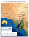 | 1,257 × 1,581 (7.58 MB) | SCHolar44 | Uploaded a work by Government of South Australia (Location SA Map Viewer) from http://location.sa.gov.au/viewer/ with UploadWizard |
File usage
The following pages on the English Wikipedia use this file (pages on other projects are not listed):
Global file usage
The following other wikis use this file:
- Usage on fr.wikipedia.org
- Usage on ru.wikipedia.org
- Usage on www.wikidata.org
Metadata
This file contains additional information, probably added from the digital camera or scanner used to create or digitize it.
If the file has been modified from its original state, some details may not fully reflect the modified file.
| Width | 1,206 px |
|---|---|
| Height | 1,559 px |
| Compression scheme | Uncompressed |
| Pixel composition | RGB |
| Orientation | Normal |
| Number of components | 4 |
| Number of rows per strip | 27 |
| Horizontal resolution | 200 dpi |
| Vertical resolution | 200 dpi |
| Data arrangement | chunky format |