File:Mt._Fuji_and_Keiyo_petrochemical_complex.JPG
From Wikipedia, the free encyclopedia
Size of this preview: 800 × 533 pixels. Other resolutions: 320 × 213 pixels | 640 × 427 pixels | 1,024 × 683 pixels | 1,280 × 853 pixels | 2,560 × 1,707 pixels | 6,000 × 4,000 pixels.
Original file (6,000 × 4,000 pixels, file size: 16.19 MB, MIME type: image/jpeg)
| This is a file from the Wikimedia Commons. Information from its description page there is shown below. Commons is a freely licensed media file repository. You can help. |
Summary
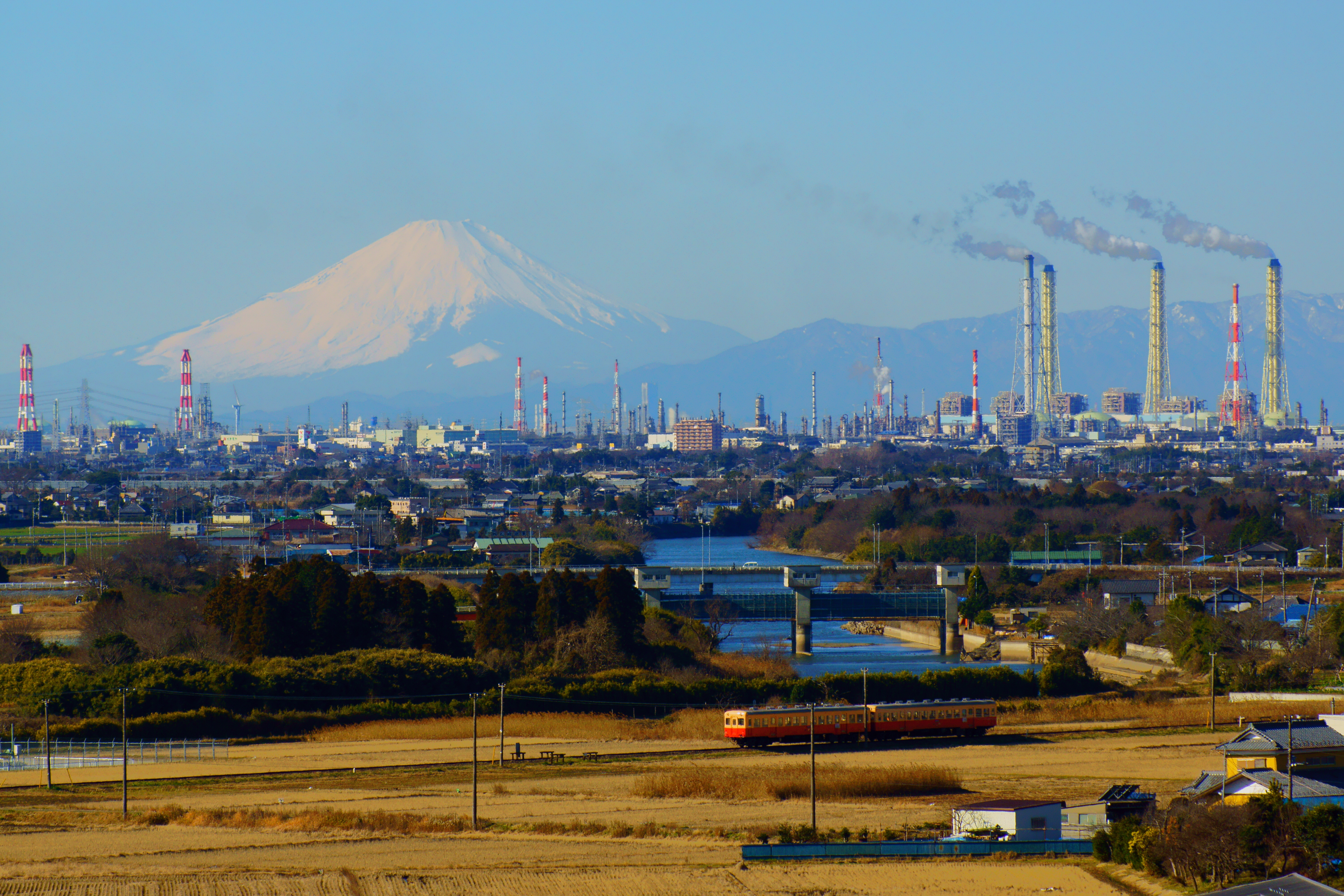
| DescriptionMt. Fuji and Keiyo petrochemical complex.JPG |
English: This is the distant view of the Keiyo industrial belt where Mt. Fuji was a background. Three chimneys in the right are Anegasaki LNG thermal power plant (3,600,000 kilowatts of output). The Highest chimney in the left of Anegasaki LNG thermal power plant is Idemitsu Chiba oil refinery (220,000 barrels of daily throughput). The chimney applied by red and white in the right is Mitsui Chemicals Chiba factory. Three chimneys in the left are Sumitomo Chemical Chiba factory. 33% of the ethylene consumed in Japan is made at Keiyo industrial belt. |
| Date | Taken on 3 January 2015 10:39:40 |
| Source | Own work |
| Author | Nanashinodensyaku |
| Camera location | 35° 29′ 14.68″ N, 140° 07′ 33.02″ E | View this and other nearby images on: OpenStreetMap |
|---|
Licensing
I, the copyright holder of this work, hereby publish it under the following license:
This file is licensed under the Creative Commons Attribution-Share Alike 4.0 International license.
- You are free:
- to share – to copy, distribute and transmit the work
- to remix – to adapt the work
- Under the following conditions:
- attribution – You must give appropriate credit, provide a link to the license, and indicate if changes were made. You may do so in any reasonable manner, but not in any way that suggests the licensor endorses you or your use.
- share alike – If you remix, transform, or build upon the material, you must distribute your contributions under the same or compatible license as the original.
Captions
Add a one-line explanation of what this file represents
Items portrayed in this file
depicts
3 January 2015
35°29'14.68"N, 140°7'33.02"E
File history
Click on a date/time to view the file as it appeared at that time.
| Date/Time | Thumbnail | Dimensions | User | Comment | |
|---|---|---|---|---|---|
| current | 06:01, 7 January 2015 | | 6,000 × 4,000 (16.19 MB) | Nanashinodensyaku | User created page with UploadWizard |
File usage
The following pages on the English Wikipedia use this file (pages on other projects are not listed):
Global file usage
The following other wikis use this file:
- Usage on ar.wikipedia.org
- Usage on ca.wikipedia.org
- Usage on ceb.wikipedia.org
- Usage on ce.wikipedia.org
- Usage on cs.wikipedia.org
- Usage on cy.wikipedia.org
- Usage on da.wikipedia.org
- Usage on de.wikipedia.org
- Usage on de.wikivoyage.org
- Usage on eu.wikipedia.org
- Usage on fr.wikivoyage.org
- Usage on ga.wikipedia.org
- Usage on gl.wikipedia.org
- Usage on he.wikipedia.org
- Usage on hy.wikipedia.org
- Usage on ja.wikipedia.org
- Usage on ko.wikipedia.org
- Usage on lt.wikipedia.org
- Usage on meta.wikimedia.org
- Usage on mn.wikipedia.org
- Usage on no.wikipedia.org
- Usage on oc.wikipedia.org
- Usage on os.wikipedia.org
- Usage on pl.wikipedia.org
- Usage on pt.wikipedia.org
- Usage on ru.wikinews.org
- Usage on sr.wikipedia.org
- Usage on tg.wikipedia.org
- Usage on tr.wikipedia.org
- Usage on tt.wikipedia.org
- Usage on vi.wikipedia.org
- Usage on www.wikidata.org
Metadata
This file contains additional information, probably added from the digital camera or scanner used to create or digitize it.
If the file has been modified from its original state, some details may not fully reflect the modified file.
| Image title | SONY DSC |
|---|---|
| Camera manufacturer | SONY |
| Camera model | SLT-A77V |
| Exposure time | 1/500 sec (0.002) |
| F-number | f/8 |
| ISO speed rating | 200 |
| Date and time of data generation | 10:39, 3 January 2015 |
| Lens focal length | 150 mm |
| Latitude | 35° 29′ 14.67″ N |
| Longitude | 140° 7′ 33.02″ E |
| Altitude | 54.727 meters above sea level |
| Orientation | Normal |
| Horizontal resolution | 350 dpi |
| Vertical resolution | 350 dpi |
| Software used | Image Data Converter |
| File change date and time | 14:09, 3 January 2015 |
| Y and C positioning | Co-sited |
| Exposure Program | Shutter priority |
| Exif version | 2.3 |
| Date and time of digitizing | 10:39, 3 January 2015 |
| Meaning of each component |
|
| Image compression mode | 8 |
| APEX brightness | 9.821875 |
| Exposure bias | 0 |
| Maximum land aperture | 4.96875 APEX (f/5.6) |
| Metering mode | Pattern |
| Light source | Unknown |
| Flash | Flash did not fire, compulsory flash suppression |
| Supported Flashpix version | 1 |
| Color space | sRGB |
| Custom image processing | Normal process |
| Exposure mode | Auto exposure |
| White balance | Auto white balance |
| Digital zoom ratio | 0 |
| Focal length in 35 mm film | 225 mm |
| Scene capture type | Standard |
| Contrast | Normal |
| Saturation | Normal |
| Sharpness | Normal |
| GPS time (atomic clock) | 01:39 |
| Receiver status | Measurement in progress |
| Measurement mode | 3-dimensional measurement |
| Measurement precision | Poor (2.168) |
| Speed unit | Kilometers per hour |
| Speed of GPS receiver | 0.205 |
| Reference for direction of movement | True direction |
| Direction of movement | 353.25 |
| Geodetic survey data used | WGS-84 |
| GPS date | 3 January 2015 |
| GPS differential correction | 0 |
| GPS tag version | 0.0.3.2 |