File:North_Sea_map-en.png
From Wikipedia, the free encyclopedia
Size of this preview: 479 × 600 pixels. Other resolutions: 192 × 240 pixels | 383 × 480 pixels | 613 × 768 pixels | 817 × 1,024 pixels | 2,475 × 3,100 pixels.
Original file (2,475 × 3,100 pixels, file size: 3.8 MB, MIME type: image/png)
| This is a file from the Wikimedia Commons. Information from its description page there is shown below. Commons is a freely licensed media file repository. You can help. |
P
Summary
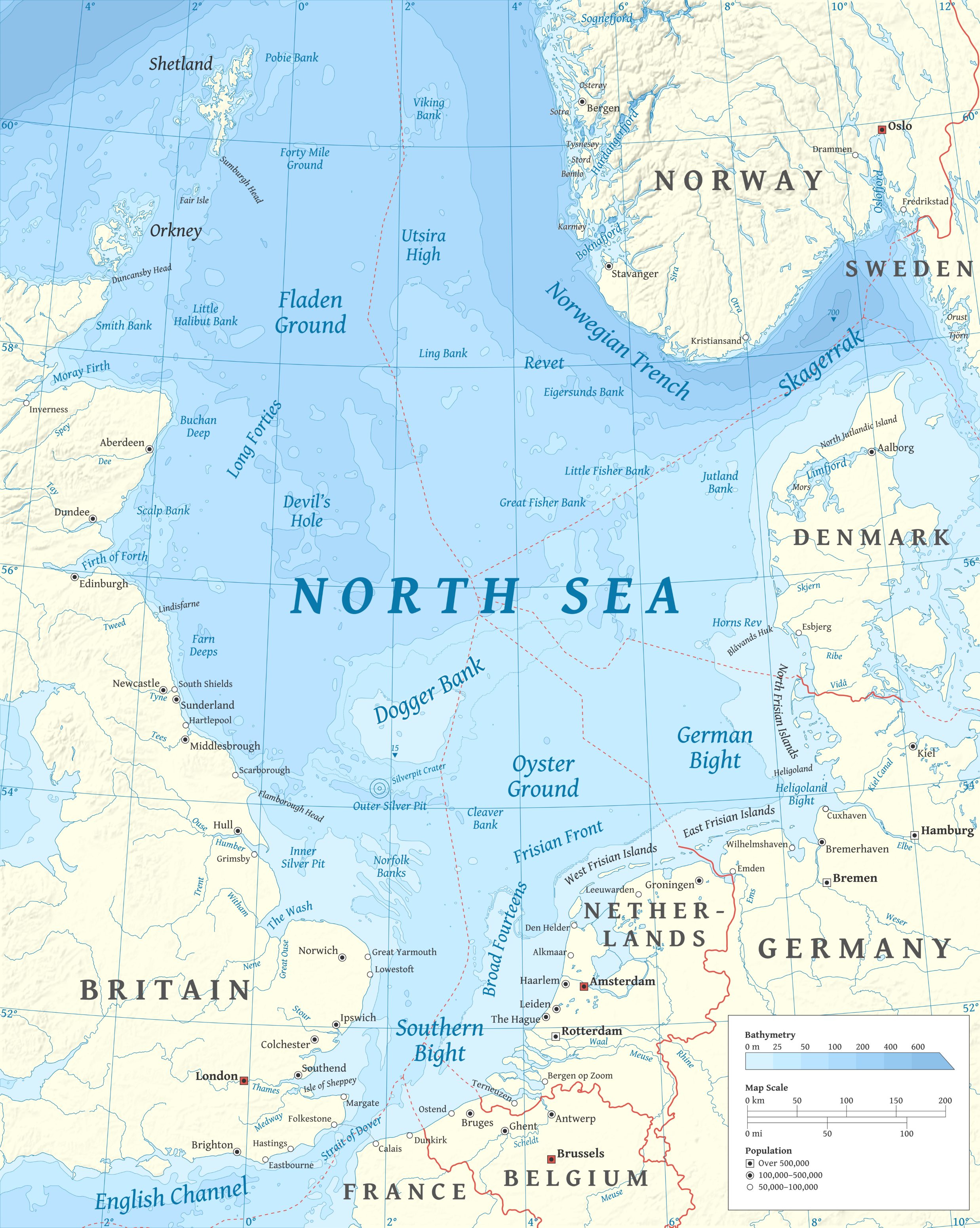
| DescriptionNorth Sea map-en.png | |
| Date | |
| Source |
Own work using en:GRASS GIS, en:Inkscape and en:GIMP. Data sources:
Map Projection: Universal Transverse Mercator Typeface: Gentium Book Basic from SIL International |
| Author | Halava |
| Other versions |
  |
Licensing
I, the copyright holder of this work, hereby publish it under the following licenses:
This file is licensed under the Creative Commons Attribution-Share Alike 3.0 Unported license.
- You are free:
- to share – to copy, distribute and transmit the work
- to remix – to adapt the work
- Under the following conditions:
- attribution – You must give appropriate credit, provide a link to the license, and indicate if changes were made. You may do so in any reasonable manner, but not in any way that suggests the licensor endorses you or your use.
- share alike – If you remix, transform, or build upon the material, you must distribute your contributions under the same or compatible license as the original.

|
Permission is granted to copy, distribute and/or modify this document under the terms of the GNU Free Documentation License, Version 1.2 or any later version published by the Free Software Foundation; with no Invariant Sections, no Front-Cover Texts, and no Back-Cover Texts. A copy of the license is included in the section entitled GNU Free Documentation License.http://www.gnu.org/copyleft/fdl.htmlGFDLGNU Free Documentation Licensetruetrue |
You may select the license of your choice.
| Annotations InfoField | This image is annotated: View the annotations at Commons |
2149
2258
181
160
2475
3100
Wrongly labled. Weser is actually the Aller flowing into the Weser on the west.
Captions
Add a one-line explanation of what this file represents
Items portrayed in this file
depicts
6 October 2010
File history
Click on a date/time to view the file as it appeared at that time.
| Date/Time | Thumbnail | Dimensions | User | Comment | |
|---|---|---|---|---|---|
| current | 17:23, 5 March 2015 | | 2,475 × 3,100 (3.8 MB) | Tandru7 | {{Information |Description=Map of the North Sea |Source=Wiki Commons |Date=3/5/15 |Author= |Permission= |other_versions= }} |
| 14:48, 15 October 2010 |  | 2,475 × 3,100 (3.8 MB) | Halava | New place names | |
| 17:34, 12 October 2010 |  | 2,475 × 3,100 (3.79 MB) | Halava | Some corrections; several new place names | |
| 11:02, 12 October 2010 |  | 2,475 × 3,100 (3.78 MB) | Halava | Minor corrections; improved legibility; Horns Rev | |
| 08:09, 10 October 2010 |  | 2,475 × 3,100 (3.72 MB) | Halava | Exclusive economic zones; Heligoland | |
| 09:26, 9 October 2010 |  | 2,475 × 3,100 (3.64 MB) | Halava | Lindisfarne; Norfolk Banks instead of Wells Bank | |
| 20:27, 8 October 2010 |  | 2,475 × 3,100 (3.63 MB) | Halava | Outlined Dogger Bank, fixed a typo | |
| 17:04, 8 October 2010 |  | 2,475 × 3,100 (3.61 MB) | Halava | Several improvements | |
| 10:52, 6 October 2010 |  | 2,475 × 3,100 (3.37 MB) | Halava | Fixed two typos, switched color model to RGB | |
| 10:09, 6 October 2010 |  | 2,475 × 3,100 (2.57 MB) | Halava | {{Information |Description={{en|1=Map of the North Sea.}} |Source={{own}} using GRASS GIS, Inkscape and GIMP. Data sources: * Elevation and bathymetry data from NGDC ETOPO1 * Coastlines, rivers and borders from NGDC World Data Bank II * Cities from OpenS |
File usage
The following pages on the English Wikipedia use this file (pages on other projects are not listed):
- Action of 11–12 December 1917
- Action of 15 August 1917
- Action of 19 August 1916
- Action off Noordhinder Bank
- Anglo-German naval arms race
- Battle of Dogger Bank (1916)
- Bombardment of Yarmouth and Lowestoft
- Broad Fourteens
- Carbon storage in the North Sea
- Cleaver Bank
- Convoy FS 271
- Devil's Hole (North Sea)
- Dogger Bank
- First Ostend Raid
- Fisher Bank
- Fladen Ground
- HMS Africa (1905)
- HMS Britannia (1904)
- HMS Commonwealth
- HMS Dominion
- HMS Emperor of India
- HMS Hibernia (1905)
- HMS Hindustan (1903)
- HMS King Edward VII
- HMS Marlborough (1912)
- HMS Zealandia
- History of the North Sea
- Horns Rev
- Hywind Scotland
- International relations of Scotland
- List of fish of the North Sea
- Long Forties
- North Sea
- Northern North Sea basin
- Northern Patrol
- Norwegian trench
- Operation Nordmark
- Operation Wikinger
- Outer Silver Pit
- Raid on Scarborough, Hartlepool and Whitby
- Raid on Yarmouth
- SMS König Albert
- SMS Lützow
- Silver Pit
- Silverpit crater
- Skagerrak
- Southern Bight
- Utsira High
- Viking-Bergen Banks
- User:An aggressive and ambiguous amphibian's absurd and adaptable anagram alarmed all ants
- User:Buaidh
- User:Buaidh/Userbox hints
- User:CarolingianCitizen
- User:Keith-264/sandbox2
- User:Ryanmhorne/pleiades List
- User:Tandru7/sandbox/Northern North Sea basin
- User talk:Keith-264/sandbox
- Wikipedia:Userboxes/Location
- Wikipedia:Userboxes/Travel
- Template:User interest North Sea
- Template:User interest North Sea/doc
- Category:Fish of the North Sea
Global file usage
The following other wikis use this file:
- Usage on af.wikipedia.org
- Usage on ar.wikipedia.org
- Usage on arz.wikipedia.org
- Usage on ast.wikipedia.org
- Usage on ba.wikipedia.org
- Usage on be-tarask.wikipedia.org
- Usage on bg.wikipedia.org
- Usage on br.wikipedia.org
- Usage on ca.wikipedia.org
- Usage on cs.wikipedia.org
- Usage on cy.wikipedia.org
- Usage on de.wikipedia.org
- Usage on de.wikivoyage.org
- Usage on el.wikipedia.org
- Usage on en.wikivoyage.org
- Usage on eo.wikipedia.org
- Usage on es.wikipedia.org
- Usage on es.wikibooks.org
- Usage on ga.wikipedia.org
- Usage on he.wikipedia.org
- הפשיטה על סקרבורו, הרטליפול וויטבי
- הפגזת ירמות' ולואוסטופט
- ליצו (סיירת מערכה, 1913)
- אה"מ מרלבורו (1912)
- קניג אלברט (אוניית מערכה, 1912)
- אה"מ אמפרור אוף אינדיה
- אה"מ קינג אדוארד השביעי
- אה"מ בריטניה (1904)
- אה"מ ניו זילנד (1904)
- אה"מ אפריקה (1905)
- אה"מ היברניה (1905)
- אה"מ קומונוולת'
- אה"מ דומיניון
- אה"מ הינדוסטן (1903)
- Usage on hi.wikipedia.org
- Usage on hr.wikipedia.org
- Usage on hu.wikipedia.org
- Usage on hy.wikipedia.org
- Usage on ia.wikipedia.org
- Usage on id.wikipedia.org
- Usage on it.wikipedia.org
View more global usage of this file.
Retrieved from "https://en.wikipedia.org/wiki/File:North_Sea_map-en.png"