File:Pat_map.PNG
From Wikipedia, the free encyclopedia
Size of this preview: 440 × 599 pixels. Other resolutions: 176 × 240 pixels | 519 × 707 pixels.
Original file (519 × 707 pixels, file size: 23 KB, MIME type: image/png)
| This is a file from the Wikimedia Commons. Information from its description page there is shown below. Commons is a freely licensed media file repository. You can help. |
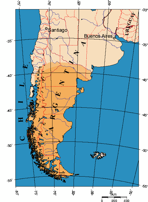
Summary
Map indicating Patagonia area in Southern South America. Modification of a GMT map.
Licensing

|
Permission is granted to copy, distribute and/or modify this document under the terms of the GNU Free Documentation License, Version 1.2 or any later version published by the Free Software Foundation; with no Invariant Sections, no Front-Cover Texts, and no Back-Cover Texts. A copy of the license is included in the section entitled GNU Free Documentation License.http://www.gnu.org/copyleft/fdl.htmlGFDLGNU Free Documentation Licensetruetrue |
| This file is licensed under the Creative Commons Attribution-Share Alike 3.0 Unported license. | ||
| ||
| This licensing tag was added to this file as part of the GFDL licensing update.http://creativecommons.org/licenses/by-sa/3.0/CC BY-SA 3.0Creative Commons Attribution-Share Alike 3.0truetrue |
Captions
Map of Patagonia
Mapo de Patagonujo
Патагония
carte de la Patagonie
Items portrayed in this file
depicts
image/png
File history
Click on a date/time to view the file as it appeared at that time.
| Date/Time | Thumbnail | Dimensions | User | Comment | |
|---|---|---|---|---|---|
| current | 22:18, 15 August 2023 | | 519 × 707 (23 KB) | Janitoalevic | Reverted to version as of 18:27, 6 November 2022 (UTC) |
| 03:02, 30 December 2022 |  | 519 × 707 (26 KB) | Wikiedro | Reverted to version as of 15:14, 12 December 2018 (UTC) | |
| 18:27, 6 November 2022 |  | 519 × 707 (23 KB) | Nihil scimus | Shaded according to the majority of maps. Chiloe does not belong to Patagonia | |
| 15:14, 12 December 2018 |  | 519 × 707 (26 KB) | Janitoalevic | Huincul Fault as northern border | |
| 00:58, 1 August 2018 |  | 519 × 707 (27 KB) | Janitoalevic | Reverted to version as of 21:14, 15 August 2017 (UTC) | |
| 23:12, 20 August 2017 |  | 519 × 707 (27 KB) | Janitoalevic | Reverted to version as of 19:06, 16 July 2016 (UTC) | |
| 21:14, 15 August 2017 |  | 519 × 707 (27 KB) | Janitoalevic | Added new chilean region | |
| 19:06, 16 July 2016 |  | 519 × 707 (27 KB) | Janitoalevic | fixed the uncolored pixel in the border. | |
| 23:47, 15 July 2016 |  | 519 × 707 (27 KB) | Janitoalevic | Added Los Ríos Region border | |
| 01:09, 2 May 2006 |  | 519 × 707 (35 KB) | Gi | Map indicating Patagonia area in Southern South America. Modification of an GMT map. |
File usage
The following pages on the English Wikipedia use this file (pages on other projects are not listed):
Global file usage
The following other wikis use this file:
- Usage on af.wikipedia.org
- Usage on ar.wikipedia.org
- Usage on ast.wikipedia.org
- Usage on az.wikipedia.org
- Usage on be-tarask.wikipedia.org
- Usage on be.wikipedia.org
- Usage on bg.wikipedia.org
- Usage on bn.wikipedia.org
- Usage on br.wikipedia.org
- Usage on bs.wikipedia.org
- Usage on ca.wikipedia.org
- Usage on cs.wikipedia.org
- Usage on cy.wikipedia.org
- Usage on da.wikipedia.org
- Usage on de.wikipedia.org
- Usage on el.wikipedia.org
- Usage on eo.wikipedia.org
- Usage on es.wikipedia.org
- Usage on es.wikisource.org
- Usage on et.wikipedia.org
- Usage on eu.wikipedia.org
- Usage on fa.wikipedia.org
- Usage on fi.wikipedia.org
- Usage on fo.wikipedia.org
- Usage on frp.wikipedia.org
- Usage on fr.wikipedia.org
- Usage on fy.wikipedia.org
- Usage on ga.wikipedia.org
- Usage on gl.wikipedia.org
- Usage on gn.wikipedia.org
- Usage on gv.wikipedia.org
- Usage on he.wikipedia.org
- Usage on hr.wikipedia.org
- Usage on hu.wikipedia.org
- Usage on hy.wikipedia.org
- Usage on id.wikipedia.org
- Usage on is.wikipedia.org
- Usage on it.wikipedia.org
- Usage on ja.wikipedia.org
- Usage on ka.wikipedia.org
- Usage on kbd.wikipedia.org
View more global usage of this file.
Metadata
This file contains additional information, probably added from the digital camera or scanner used to create or digitize it.
If the file has been modified from its original state, some details may not fully reflect the modified file.
| Horizontal resolution | 28.29 dpc |
|---|---|
| Vertical resolution | 28.29 dpc |
Retrieved from "https://en.wikipedia.org/wiki/File:Pat_map.PNG"