File:SakastanMap.jpg
From Wikipedia, the free encyclopedia
Size of this preview: 733 × 599 pixels. Other resolutions: 294 × 240 pixels | 587 × 480 pixels | 939 × 768 pixels | 1,252 × 1,024 pixels | 1,356 × 1,109 pixels.
Original file (1,356 × 1,109 pixels, file size: 258 KB, MIME type: image/jpeg)
| This is a file from the Wikimedia Commons. Information from its description page there is shown below. Commons is a freely licensed media file repository. You can help. |

|
This historical map image could be re-created using vector graphics as an SVG file. This has several advantages; see Commons:Media for cleanup for more information. If an SVG form of this image is available, please upload it and afterwards replace this template with
{{vector version available|new image name}}.
It is recommended to name the SVG file “SakastanMap.svg”—then the template Vector version available (or Vva) does not need the new image name parameter. |
 | This historical map image was uploaded in the JPEG format even though it consists of non-photographic data. This information could be stored more efficiently or accurately in the PNG or SVG format. If possible, please upload a PNG or SVG version of this image without compression artifacts, derived from a non-JPEG source (or with existing artifacts removed). After doing so, please tag the JPEG version with {{Superseded|NewImage.ext}} and remove this tag. This tag should not be applied to photographs or scans. If this image is a diagram or other image suitable for vectorisation, please tag this image with {{Convert to SVG}} instead of {{BadJPEG}}. If not suitable for vectorisation, use {{Convert to PNG}}. For more information, see {{BadJPEG}}. |  |
Summary
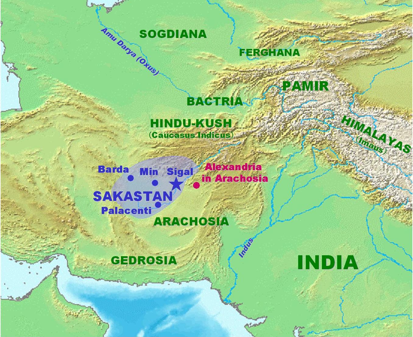
| DescriptionSakastanMap.jpg | Map of Sakastan circa 100 BCE. Own work. |
| Date | 21 January 2007 (original upload date) |
| Source | No machine-readable source provided. Own work assumed (based on copyright claims). |
| Author | No machine-readable author provided. World Imaging assumed (based on copyright claims). |
Licensing
| Public domainPublic domainfalsefalse |
| I, the copyright holder of this work, release this work into the public domain. This applies worldwide. In some countries this may not be legally possible; if so: I grant anyone the right to use this work for any purpose, without any conditions, unless such conditions are required by law. |
Captions
Map of Sakastan circa 100 B.C.
শকস্তানের মানচিত্র (আনুমানিক খ্রিষ্টপূর্ব ১০০ অব্দ)
Items portrayed in this file
depicts
File history
Click on a date/time to view the file as it appeared at that time.
| Date/Time | Thumbnail | Dimensions | User | Comment | |
|---|---|---|---|---|---|
| current | 21:22, 21 January 2007 | | 1,356 × 1,109 (258 KB) | World Imaging | More precise map, with Arachosia. |
| 21:05, 21 January 2007 |  | 1,353 × 1,112 (260 KB) | World Imaging | Map of Sakastan circa 100 BCE. Own work. |
File usage
The following pages on the English Wikipedia use this file (pages on other projects are not listed):
Global file usage
The following other wikis use this file:
- Usage on af.wikipedia.org
- Usage on arz.wikipedia.org
- Usage on bcl.wikipedia.org
- Usage on bn.wikipedia.org
- Usage on ca.wikipedia.org
- Usage on cs.wikipedia.org
- Usage on de.wikipedia.org
- Usage on diq.wikipedia.org
- Usage on eo.wikipedia.org
- Usage on es.wikipedia.org
- Usage on et.wikipedia.org
- Usage on fa.wikipedia.org
- Usage on hu.wikipedia.org
- Usage on incubator.wikimedia.org
- Usage on it.wikipedia.org
- Usage on ka.wikipedia.org
- Usage on ml.wikipedia.org
- Usage on ne.wikipedia.org
- Usage on nl.wikipedia.org
- Usage on pa.wikipedia.org
- Usage on pl.wikipedia.org
- Usage on pl.wiktionary.org
- Usage on ps.wikipedia.org
- Usage on ro.wikipedia.org
- Usage on ru.wikipedia.org
- Usage on simple.wikipedia.org
- Usage on sr.wikipedia.org
- Usage on sv.wikipedia.org
- Usage on sw.wikipedia.org
- Usage on ta.wikipedia.org
- Usage on tl.wikipedia.org
- Usage on uk.wikipedia.org
- Usage on ur.wikipedia.org
- Usage on vi.wikipedia.org
- Usage on www.wikidata.org
- Usage on zh.wikipedia.org
Metadata
This file contains additional information, probably added from the digital camera or scanner used to create or digitize it.
If the file has been modified from its original state, some details may not fully reflect the modified file.
| _error | 0 |
|---|
Retrieved from "https://en.wikipedia.org/wiki/File:SakastanMap.jpg"