File:Water_stress_2019_WRI.png
From Wikipedia, the free encyclopedia
Original file (1,425 × 625 pixels, file size: 54 KB, MIME type: image/png)
| This is a file from the Wikimedia Commons. Information from its description page there is shown below. Commons is a freely licensed media file repository. You can help. |
Summary
| DescriptionWater stress 2019 WRI.png |
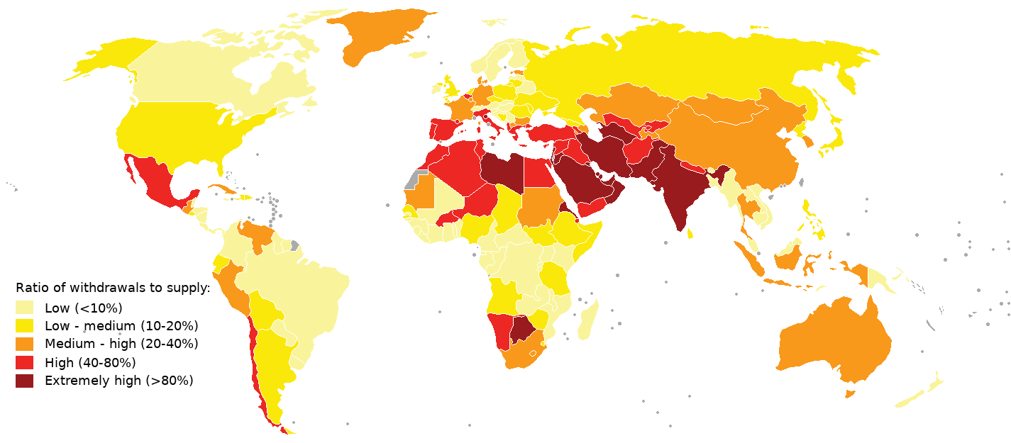
English: 2019 water stress map.
Compiled using aqueduct 3.0 data from World Resources Institute See table "National Water Stress Rankings" at https://www.wri.org/blog/2019/08/17-countries-home-one-quarter-world-population-face-extremely-high-water-stress and https://www.wri.org/applications/aqueduct/country-rankings/ Legend was made similar as in an earlier WRI map (aqueduct 2.0), see https://www.wri.org/resources/data-sets/aqueduct-projected-water-stress-country-rankings What's colored in grey means no data available (i.e. western sahara, french guyana) |
| Date | |
| Source | Own work |
| Author | Genetics4good |
Licensing

|
Permission is granted to copy, distribute and/or modify this document under the terms of the GNU Free Documentation License, Version 1.2 or any later version published by the Free Software Foundation; with no Invariant Sections, no Front-Cover Texts, and no Back-Cover Texts. A copy of the license is included in the section entitled GNU Free Documentation License.http://www.gnu.org/copyleft/fdl.htmlGFDLGNU Free Documentation Licensetruetrue |
Captions
Items portrayed in this file
depicts
some value
11 August 2019
image/png
File history
Click on a date/time to view the file as it appeared at that time.
| Date/Time | Thumbnail | Dimensions | User | Comment | |
|---|---|---|---|---|---|
| current | 13:38, 11 August 2019 | | 1,425 × 625 (54 KB) | Genetics4good | {{Information |description ={{en|1=2019 water stress map. Compiled using aqueduct 3.0 data from World Resources Institute See table "National Water Stress Rankings" at https://www.wri.org/blog/2019/08/17-countries-home-one-quarter-world-population-face-extremely-high-water-stress and https://www.wri.org/applications/aqueduct/country-rankings/ Legend was made similar as in an earlier WRI map (aqueduct 2.0), see https://www.wri.org/resources/data-sets/aqueduct-projected-water-stress-country-r... |
File usage
Global file usage
The following other wikis use this file:
- Usage on el.wikipedia.org
- Usage on fr.wikipedia.org
- Usage on hi.wikipedia.org
- Usage on it.wikipedia.org
- Usage on ja.wikipedia.org
- Usage on ms.wikipedia.org
- Usage on nl.wikipedia.org
- Usage on pt.wikipedia.org
- Usage on sv.wikipedia.org
- Usage on te.wikipedia.org
- Usage on uk.wikipedia.org
- Usage on www.wikidata.org
- Usage on zh.wikipedia.org
Metadata
This file contains additional information, probably added from the digital camera or scanner used to create or digitize it.
If the file has been modified from its original state, some details may not fully reflect the modified file.
| Horizontal resolution | 37.8 dpc |
|---|---|
| Vertical resolution | 37.8 dpc |
| File change date and time | 13:27, 11 August 2019 |