
Puerto Rico Highway 798
Highway in Puerto Rico / From Wikipedia, the free encyclopedia
Dear Wikiwand AI, let's keep it short by simply answering these key questions:
Can you list the top facts and stats about Puerto Rico Highway 798?
Summarize this article for a 10 year old
SHOW ALL QUESTIONS
Puerto Rico Highway 798 (PR-798) is a road located between the municipalities of Caguas, Puerto Rico, and San Juan,[4] and it corresponds to an original segment of the historic Carretera Central.[5] La Concepción Bridge is located on this route.[5]
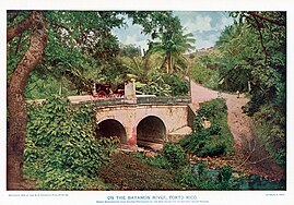 La Concepción Bridge (1899)
 Puerto Rico Highway 798 south in Río Cañas, Caguas
,_Barrio_Rio_Cañas,_Caguas,_Puerto_Rico_(1899).jpg)

Quick Facts Highway 798, Route information ...
Highway 798 | ||||
|---|---|---|---|---|
| Ruta 798 | ||||
| Route information | ||||
| Maintained by Puerto Rico DTPW | ||||
| Length | 4.6 km[1][2][3] (2.9 mi) | |||
| Major junctions | ||||
| South end | ||||
| Major intersections | ||||
| North end | ||||
| Location | ||||
| Country | United States | |||
| Territory | Puerto Rico | |||
| Municipalities | Caguas, San Juan | |||
| Highway system | ||||
| ||||

Close