File:Abbasids850.png
From Wikipedia, the free encyclopedia
Size o this luikower: 800 × 487 pixels. Ither resolutions: 320 × 195 pixels | 640 × 390 pixels | 1,024 × 624 pixels | 1,481 × 902 pixels.
Oreeginal file (1,481 × 902 pixels, file size: 50 KB, MIME type: image/png)
This file is fae Wikimedia Commons n micht be uised bi ither waurks. The descreeption oan its file descreeption page thaur is shawn ablo.
Ootline
| DescreeptionAbbasids850.png |
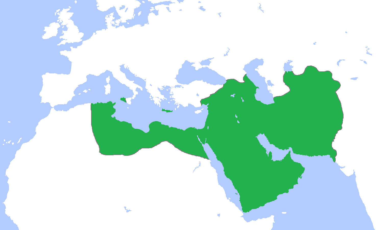
English: Map of the Abbasid Caliphate at its greatest extent, c. 850.
(Partially based on Atlas of World History (2007) - Progress of Islam, map)
العربية: :خريطة الدولة العباسية في أقصى اتساعها. |
| Date | |
| Soorce | Ain wirk |
| Author | Gabagool |
| Other versions | Derivative works of this file: IslamicWorld850.png |

|
File:Abbassids 850 (orthographic projection).svg is a vector version o this file. It should be uised in place o this raster image when nae inferior.
File:Abbasids850.png → File:Abbassids 850 (orthographic projection).svg
For mair information, see Help:SVG.
|
.svg) |
Licensin
I, the copyright holder of this work, hereby publish it under the following license:
This file is licensed under the Creative Commons Attribution 3.0 Unported license.
- Ye are free:
- tae share – tae copy, distribute an transmit the wirk
- tae remix – tae adapt the wirk
- Unner the follaein condeetions:
- attribution – Ye must attribute the wirk in the manner specified bi the author or licensor (but nae in ony way that suggests that thay endorse ye or yer uise o the wirk).
Captions
Add a one-line explanation of what this file represents
نقشه خلافت عباسی در بزرگترین گستره آن، ۸۵۰م. (تا حدی بر اساس اطلس تاریخ جهان (۲۰۰۷) - پیشرفت اسلام، نقشه)
خريطة الدولة العباسية في أقصى اتساعها.
Items portrayed in this file
depicts
some value
copyright status Inglis
copyrighted Inglis
21 Apryle 2009
source of file Inglis
image/png
checksum Inglis
37d11d5e8705bcd600059a55fdab1ddc8c190a05
data size Inglis
51,274 byte
902 pixel
width Inglis
1,481 pixel
File history
Clap oan ae date/time fer tae see the file aes it kithed at that time.
| Date/Time | Thummnail | Dimensions | Uiser | Comment | |
|---|---|---|---|---|---|
| current | 10:42, 25 Mairch 2012 | | 1,481 × 902 (50 KB) | Cplakidas | corrections: the eastern half of Sicily was still in Byz. hands, as was Malta. Sardinia and Corsica were raided but never conquered |
| 15:28, 22 Apryle 2009 |  | 1,481 × 902 (50 KB) | Gabagool | some corrections.. | |
| 16:28, 21 Apryle 2009 |  | 1,481 × 902 (50 KB) | Gabagool | {{Information |Description={{en|1=Map of the Abbasid Caliphat at its greatest extent, c. 850. (Partially based on ''Atlas of World History'' (2007) - Progress of Islam, map)}} |Source=Own work by uploader |Author=Gabagool / Jarle Grøhn |
Eimage airtins
The follaein pages airts tae this image:
Global file uisage
The follaein ither wikis uise this file:
- Uisage on af.wikipedia.org
- Uisage on als.wikipedia.org
- Uisage on an.wikipedia.org
- Uisage on ar.wikipedia.org
- Uisage on arz.wikipedia.org
- Uisage on ast.wikipedia.org
- Uisage on azb.wikipedia.org
- Uisage on bat-smg.wikipedia.org
- Uisage on be-tarask.wikipedia.org
- Uisage on be.wikipedia.org
- Uisage on bg.wikipedia.org
- Uisage on bn.wikipedia.org
- Uisage on br.wikipedia.org
- Uisage on bs.wikipedia.org
- Uisage on bxr.wikipedia.org
- Uisage on ca.wikipedia.org
- Uisage on cbk-zam.wikipedia.org
- Uisage on ckb.wikipedia.org
- Uisage on cs.wikipedia.org
- Uisage on da.wikipedia.org
- Uisage on de.wikipedia.org
- Uisage on diq.wikipedia.org
- Uisage on en.wikipedia.org
View mair global usage o this file.