File:NabateensRoutes.png
From Wikipedia, the free encyclopedia
Size of this preview: 616 × 599 pixels. Other resolutions: 247 × 240 pixels | 494 × 480 pixels | 837 × 814 pixels.
Original file (837 × 814 pixels, file size: 56 KB, MIME type: image/png)
| This is a file from the Wikimedia Commons. Information from its description page there is shown below. Commons is a freely licensed media file repository. You can help. |

|
This ethnographic map image could be re-created using vector graphics as an SVG file. This has several advantages; see Commons:Media for cleanup for more information. If an SVG form of this image is available, please upload it and afterwards replace this template with
{{vector version available|new image name}}.
It is recommended to name the SVG file “NabateensRoutes.svg”—then the template Vector version available (or Vva) does not need the new image name parameter. |
Summary
| DescriptionNabateensRoutes.png |
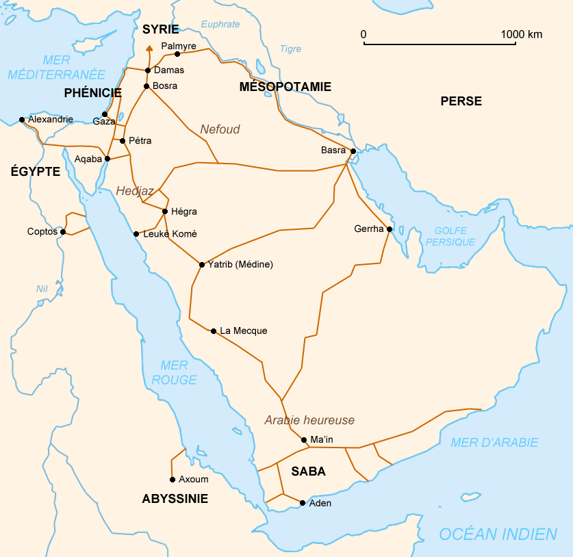
English: Nabataeans' commercial roads
العربية: خريطة توضح الطرق التجارية للأنباط |
| Date | (UTC) |
| Source | Own work (using different GFDL maps so it may be not exactly right) and the book : Christian Augé et Jean-Marie Dentzer, Pétra, la cité des caravanes, Gallimard, coll. « Découvertes Gallimard / Archéologie », Paris, avril 1999 (réimpr. 2001, 2004, 2006), 96 p. (ISBN 2-07-053428-6) |
| Author | Like tears in rain (Contact me for suggestions/corrections) |
| Other versions | Derivative works of this file: NabateensRoutesHe.png |
{-_-} Like tears in rain
Licensing
I, the copyright holder of this work, hereby publish it under the following licenses:

|
Permission is granted to copy, distribute and/or modify this document under the terms of the GNU Free Documentation License, Version 1.2 or any later version published by the Free Software Foundation; with no Invariant Sections, no Front-Cover Texts, and no Back-Cover Texts. A copy of the license is included in the section entitled GNU Free Documentation License.http://www.gnu.org/copyleft/fdl.htmlGFDLGNU Free Documentation Licensetruetrue |
| This file is licensed under the Creative Commons Attribution-Share Alike 3.0 Unported license. | ||
| ||
| This licensing tag was added to this file as part of the GFDL licensing update.http://creativecommons.org/licenses/by-sa/3.0/CC BY-SA 3.0Creative Commons Attribution-Share Alike 3.0truetrue |
This file is licensed under the Creative Commons Attribution-Share Alike 2.5 Generic, 2.0 Generic and 1.0 Generic license.
- You are free:
- to share – to copy, distribute and transmit the work
- to remix – to adapt the work
- Under the following conditions:
- attribution – You must give appropriate credit, provide a link to the license, and indicate if changes were made. You may do so in any reasonable manner, but not in any way that suggests the licensor endorses you or your use.
- share alike – If you remix, transform, or build upon the material, you must distribute your contributions under the same or compatible license as the original.
You may select the license of your choice.
Captions
Add a one-line explanation of what this file represents
Items portrayed in this file
depicts
image/png
File history
Click on a date/time to view the file as it appeared at that time.
| Date/Time | Thumbnail | Dimensions | User | Comment | |
|---|---|---|---|---|---|
| current | 15:50, 12 May 2007 | | 837 × 814 (56 KB) | Like tears in rain | == Summary == {{Information |Description={{en|Nabataeans' commercial roads}} |Source= Own work (using different GFDL maps <u>so it may be not exactly right</u>) and the book : Christian Augé et Jean-Marie Dentzer, ''Pétra, la cité des caravanes'', Gall |
File usage
The following pages on the English Wikipedia use this file (pages on other projects are not listed):
Global file usage
The following other wikis use this file:
- Usage on af.wikipedia.org
- Usage on ar.wikipedia.org
- Usage on ast.wikipedia.org
- Usage on az.wikipedia.org
- Usage on bn.wikipedia.org
- Usage on bs.wikipedia.org
- Usage on ca.wikipedia.org
- Usage on de.wikipedia.org
- Usage on el.wikipedia.org
- Usage on es.wikipedia.org
- Usage on fi.wikibooks.org
- Usage on fr.wikipedia.org
- Usage on fr.wikibooks.org
- Usage on fy.wikipedia.org
- Usage on gl.wikipedia.org
- Usage on he.wikipedia.org
- Usage on hi.wikipedia.org
- Usage on hu.wikipedia.org
- Usage on hy.wikipedia.org
- Usage on hyw.wikipedia.org
- Usage on id.wikipedia.org
- Usage on it.wikipedia.org
- Usage on ja.wikipedia.org
- Usage on ka.wikipedia.org
- Usage on lt.wikipedia.org
- Usage on mg.wikipedia.org
- Usage on ms.wikipedia.org
- Usage on mt.wikipedia.org
- Usage on nl.wikipedia.org
- Usage on no.wikipedia.org
- Usage on oc.wikipedia.org
View more global usage of this file.
Retrieved from "https://en.wikipedia.org/wiki/File:NabateensRoutes.png"