Portal:New Guinea
Wikipedia portal for content related to New Guinea / From Wikipedia, the free encyclopedia
Portal maintenance status: (April 2022)
|
Native name: Papua, Niugini, Niu Gini | |
|---|---|
 | |
| Geography | |
| Location | Oceania (Melanesia) |
| Archipelago | Melanesia and Malay Archipelago |
| Area | 785,753 km2 (303,381 sq mi) |
| Area rank | 2nd |
The New Guinea Portal
Introduction

New Guinea (Tok Pisin: Niugini; Hiri Motu: Niu Gini; Indonesian: Papua, fossilized Nugini, or historically Irian) is the world's second-largest island, with an area of 785,753 km2 (303,381 sq mi). Located in Melanesia in the southwestern Pacific Ocean, the island is separated from Australia by the 150-kilometre (81-nautical-mile; 93-mile) wide Torres Strait, though both landmasses lie on the same continental shelf, and were united during episodes of low sea level in the Pleistocene glaciations as the combined landmass of Sahul. Numerous smaller islands are located to the west and east. The island's name was given by Spanish explorer Yñigo Ortiz de Retez during his maritime expedition of 1545 due to the resemblance of the indigenous peoples of the island to those in the African region of Guinea. (Full article...)
Papua New Guinea, officially the Independent State of Papua New Guinea, is a country in Oceania that comprises the eastern half of the island of New Guinea and its offshore islands in Melanesia (a region of the southwestern Pacific Ocean north of Australia). It shares its only land border with Indonesia to the west and it is directly adjacent to Australia to the south and the Solomon Islands to the east. Its capital, located on its southern coast, is Port Moresby. The country is the world's third largest island country, with an area of 462,840 km2 (178,700 sq mi). (Full article...)
Western New Guinea, also known as Papua, Indonesian New Guinea, and Indonesian Papua, is the western, formerly Dutch presently Indonesian, half of the island of New Guinea, granted to Indonesia in 1962. Given the island is alternatively named Papua, the region is also called West Papua (Indonesian: Papua Barat). (Full article...)
Selected article - load new batch
 Image 1
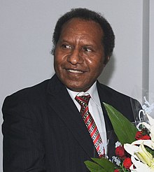 Abal in 2009
Samuel Tei Abal (born 26 June 1958) is a Papua New Guinean politician. Abal, who previously served as Foreign Minister from August 2007 to December 2010, became the Deputy Prime Minister of the country in a cabinet reshuffle by Michael Somare on 7 December 2010. He further became acting Prime Minister of Papua New Guinea on 13 December 2010, when Prime Minister Somare stepped down from office to face a tribunal regarding allegations of financial mismanagement. His tenure as acting Prime Minister ended on 2 August 2011, when Peter O'Neill won a parliamentary vote to be appointed as Prime Minister. Since October 2021, he is the Ambassador Extraordinary and Plenipotentiary of Papua New Guinea to Japan. (Full article...)- Image 2

Regional map with West New Guinea highlighted. To the west, the Moluccas in Indonesia; to the east, the Australian Territory of Papua and New Guinea (now Papua New Guinea); to the south, mainland Australia.
The New York Agreement is an agreement signed by the Netherlands and Indonesia regarding the administration of the territory of Western New Guinea. The first part of the agreement proposes that the United Nations assume administration of the territory, and a second part proposes a set of social conditions that will be provided if the United Nations exercises a discretion proposed in article 12 of the agreement to allow Indonesian occupation and administration of the territory. Negotiated during meetings hosted by the United States, the agreement was signed on 15 August 1962 at the United Nations Headquarters in New York City, United States.
The agreement was added to the agenda of the 1962 United Nations General Assembly and precipitated General Assembly Resolution 1752 (XVII) granting the United Nations authority to occupy and administer West New Guinea. Although agreements are not able to negate obligations defined in the Charter of the United Nations, and the agreement asserted that it was for the benefit of the people of the territory, some people believed that the agreement was sacrificing the people of the territory for the benefit of the foreign powers.
A United States Department of State summary from 1962 asserts the "agreement was almost a total victory for Indonesia and a defeat for the Netherlands", that the United States "Bureau of European Affairs was sympathetic to the Dutch view that annexation by Indonesia would simply trade white for brown colonialism", and that "The underlying reason that the Kennedy administration pressed the Netherlands to accept this agreement was that it believed that Cold War considerations of preventing Indonesia from going Communist overrode the Dutch case." (Full article...) - Image 3

Map of Melanesia, showing its location within Oceania
Melanesia (UK: /ˌmɛləˈniːziə/, US: /ˌmɛləˈniːʒə/) is a subregion of Oceania in the southwestern Pacific Ocean. It extends from New Guinea in the west to the Fiji Islands in the east, and includes the Arafura Sea.
The region includes the four independent countries of Fiji, Vanuatu, Solomon Islands, and Papua New Guinea. It also includes the Indonesian part of New Guinea, the French oversea collectivity of New Caledonia, and the Torres Strait Islands. Almost all of the region is in the Southern Hemisphere; only a few small islands that are not politically considered part of Oceania—specifically the northwestern islands of Western New Guinea—lie in the Northern Hemisphere.
The name Melanesia (in French, Mélanésie) was first used in 1832 by French navigator Jules Dumont d'Urville: he coined the terms Melanesia and Micronesia to go alongside the pre-existing Polynesia to designate what he viewed as the three main ethnic and geographical regions forming the Pacific. (Full article...) - Image 4
 Marape in 2023
James Marape (born 24 April 1971) is a Papua New Guinean politician who has served as the prime minister of Papua New Guinea since May 2019. He has been a member of the National Parliament of Papua New Guinea since July 2007, representing the electorate of Tari-Pori Open in Hela Province in the New Guinea Highlands. He has held Cabinet Posts as Minister of Education (2008–2011), Minister of Finance (2012–2019), and Minister of Foreign Affairs (2023–present). Marape entered the 2022 elections under the banner of the Pangu Party and won more seats than any other party. He was therefore entitled to form the government. His new government was elected unopposed by the new parliament. (Full article...) - Image 5The Nduga massacre (Indonesian: Pembantaian Nduga) was a shooting of construction workers that occurred on 1 December 2018, in Nduga Regency, Papua (now in Highland Papua), Indonesia. The shooting is considered to be part of the Papuan conflict. The West Papua National Liberation Army (TPNPB) acknowledged responsibility and the Indonesian government labeled the attack a massacre. (Full article...)
- Image 6
 Copper ore concentrator undergoing construction, c. 1971
The Panguna mine is a large copper mine located in Bougainville, Papua New Guinea. Panguna represents one of the largest copper reserves in Papua New Guinea and in the world, having an estimated reserve of one billion tonnes of ore copper and twelve million ounces of gold. The mine has been closed since 1989 and has ceased all production. (Full article...) - Image 7
 An Australian soldier of the AN&MEF and his mother in Sydney, 1914, prior to departing for Rabaul
The Battle of Bita Paka (11 September 1914) was fought south of Kabakaul, on the island of New Britain, and was a part of the invasion and subsequent occupation of German New Guinea by the Australian Naval and Military Expeditionary Force (AN&MEF) shortly after the outbreak of the First World War. Similar to New Zealand's operation against German Samoa in August, the main target of the operation was a strategically important wireless station—one of several used by the German East Asia Squadron—which the Australians believed to be located in the area. The powerful German naval fleet threatened British interests and its elimination was an early priority of the British and Australian governments during the war.
After an unopposed landing, a mixed force of German reservists and half-trained Melanesian police mounted a stout resistance and forced the Australians to fight their way to the objective. After a day of fighting during which both sides suffered casualties, Australian forces captured the wireless station at Bita Paka. The battle was Australia's first major military engagement of the war and the only significant action of the campaign; in its aftermath the remaining German forces on New Britain fled inland to Toma. Following a brief siege there the German garrison capitulated, ending resistance to the Australian occupation of the island. (Full article...) - Image 8

Sorong is the largest city and the capital of the Indonesian province of Southwest Papua. The city is located on the western tip of the island of New Guinea with its only land borders being with Sorong Regency. It is the gateway to Indonesia's Raja Ampat Islands, species rich coral reef islands in an area considered the heart of the world's coral reef biodiversity. It also is the logistics hub for Indonesia's thriving eastern oil and gas frontier. Sorong experienced rapid growth during the decade from 2010, and further growth is anticipated as Sorong becomes linked by road to other frontier towns in Papua's Bird's Head Peninsula. The official estimate of population as at mid 2023 was 294,978 - comprising 154,543 males and 140,435 females. The suburban area of Sorong city contains tropical rainforest and mangrove forest that has increasingly become popular as ecotourism attractions especially for birdwatching or wildlife watching. (Full article...) - Image 9
 Looking out across the lower half of the Porgera processing plant, and down into the Porgera valley
The Porgera Gold Mine is a large gold and silver mining operation near Porgera, Enga province, Papua New Guinea (PNG). Located at the head of the Porgera Valley, The mine is situated in the rain forest covered highlands at an altitude of 2,200 to 2,700 m, in a region of high rainfall, landslides, and frequent earthquakes.
The Porgera Gold Mine closed in April 2020, following the end of its special mining lease. Extensive negotiations for a new special mining lease were concluded in 2023 and the reopening of the mine was announced in December 2023, with first production expected in the first quarter of 2024.
The new special mining lease was finally issued to New Porgera Limited, an entity 51% owned by PNG stakeholders (including state-owned Kumul Minerals Holdings Limited, local landowners and the Enga provincial government), and 49% by Barrick Niugini Limited (BNL), itself a joint venture between Barrick Gold and Zijin Mining of China. (Full article...) - Image 10
 Troops unloading supplies at Aitape
The Landing at Aitape (code-named Operation Persecution) was a battle of the Western New Guinea campaign of World War II. American and Allied forces undertook an amphibious landing on 22 April 1944 at Aitape on the northern coast of Papua New Guinea. The amphibious landing was undertaken simultaneously with the landings at Humboldt and Tanahmerah Bays to secure Hollandia to isolate the Japanese 18th Army at Wewak. Operations in the area to consolidate the landing continued until 4 May, although US and Japanese forces fought further actions in western New Guinea following a Japanese counter-offensive that lasted until early August 1944. Aitape was subsequently developed into an Allied base of operations and was used by Australian forces throughout late 1944 and into 1945 during the Aitape–Wewak campaign. (Full article...) - Image 11PNG Football Stadium , known by the sponsored name of Santos National Football Stadium and previously as Lloyd Robson Oval until 2015, is a sporting ground in Port Moresby, Papua New Guinea. It hosted three games for the 1989–1992 Rugby League World Cup. It has been the home ground for the Papua New Guinea national rugby league team since 1975. It has a total capacity of approximately 15,000 and is the National Stadium of Papua New Guinea. The stadium was completely redeveloped in preparation for the 2015 Pacific Games. (Full article...)
- Image 12
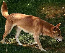
The New Guinea singing dog or New Guinea Highland dog (Canis lupus hallstromi) is an ancient (basal) lineage of dog found in the New Guinea Highlands, on the island of New Guinea. Once considered to be a separate species in its own right, under the name Canis hallstromi, it is closely related to the Australian dingo. The dog is relatively unusual among canines; it is one of the few to be considered "barkless", and is known for the unusual "yodel"-like style of vocalizing that gives it its name.
In 1989, the Australian mammalogist Tim Flannery took a photo of a black-and-tan dog in Telefomin District. He noted that these dogs lived with local tribal peoples in the mountains, and that feral populations lived in the alpine and sub-alpine grasslands of the Star Mountains and the Wharton Range. The photo was published in his book, Mammals of New Guinea. In 2012, Australian wilderness-adventure guide Tom Hewett took a photo of a tawny, thick-coated dog in the Puncak Mandala region of West Papua, Indonesia. In 2016, a literature review found no definitive evidence that the earliest possible dogs, within captive populations of New Guinea singing dogs, were wild animals; successive generations of puppies were raised as members of village populations, thus being domestic dogs.
In 2020, a genetic study found that the New Guinea Highland wild dogs were genetically basal to the dingo and the New Guinea singing dog, and therefore the potential originator of both. (Full article...) - Image 13Bougainville, an autonomous region of Papua New Guinea (PNG), has been inhabited by humans for at least 29,000 years, according to artefacts found in Kilu Cave on Buka Island. The region is named after Bougainville Island, the largest island of the Solomon Islands archipelago, but also contains a number of smaller islands.
The first arrivals in Bougainville were ethnically Australo-Melanesian, related to Papuans and Aboriginal Australians. Around 3,000 years ago, Austronesians associated with the Lapita culture also settled on the islands, bringing agriculture and pottery. Present-day Bougainvilleans are descended from a mixture of the two populations, and both Austronesian and non-Austronesian languages are spoken to this day.
In 1616, Dutch explorers Willem Schouten and Jacob Le Maire became the first Europeans to sight the islands. The main island was named after French admiral Louis Antoine de Bougainville, who reached it in 1768. The German Empire placed Bougainville under a protectorate in 1886, while the remainder of the Solomon Islands became part of the British Empire in 1893. The present-day boundaries between Papua New Guinea and Solomon Islands were established by the Tripartite Convention of 1899. The incorporation of Bougainville into German New Guinea initially had little economic impact, although the associated Catholic missions succeeded in converting a majority of the islanders to Christianity. (Full article...) - Image 14
 Satellite image
Kokopo is the capital of East New Britain Province in Papua New Guinea. It is administered under Kokopo/Vunamami Urban LLG. The capital was moved from Rabaul in 1994 when the volcanoes Tavurvur and Vulcan erupted. As a result, the population of the town increased more than sixfold from 3,150 in 1990 to 20,262 in 2000.
Kokopo was known as Herbertshöhe (Herbert's Heights), named in honour of Herbert, eldest son of German Chancellor Otto von Bismarck, during the German New Guinea administration, which controlled the area between 1884 and formally until 1919. Until 1910, it was the capital of German New Guinea.
On Sunday, March 29, 2015, a strong earthquake, of a preliminary magnitude of at least 7.5, which at that time was the largest earthquake of 2015, was recorded near Kokopo, and a tsunami warning was issued. This was surpassed a month later by the April 2015 Nepal earthquake, which measured a magnitude 7.8. (Full article...) - Image 15The KPHL National Soccer League, also known as the Kumul Petroleum Holdings Limited National Soccer League for sponsorship reasons, is the men's top division of professional soccer in Papua New Guinea. It is a nationwide league formed in 2006 by Papua New Guinea Football Association.
It replaced the Papua New Guinea National Club Championship as the country's major soccer competition.
The competition has been won by only two clubs. Hekari United won the first eight editions, while Lae City have won the rest. The two clubs have met in two Grand Finals, in 2015–16 and 2019, with Lae City winning both. (Full article...)

.jpg)


.jpg)

.jpg)


Did you know (auto-generated)

- ... that Dorkas Tokoro-Hanasbey, the only female member of the New Guinea Council, arrived thirty minutes late to her inauguration ceremony?
- ... that the clinical trials of British scientist Peter Pharoah helped eradicate congenital iodine deficiency syndrome (cretinism) in Papua New Guinea?
- ... that until Rufina Peter and Kessy Sawang's election in August 2022, Papua New Guinea was one of only three countries without a woman in parliament?
- ... that Australian official Jack Emanuel was awarded the George Cross in 1971 after being stabbed to death whilst trying to resolve a land dispute with the Tolai people of New Guinea?
- ... that Australiformis semoni is a parasite that infests marsupials in Australia and New Guinea and whose infestation could cause debilitating ulcerative granulomatous gastritis?
- ... that David Dexter, who wrote the New Guinea volume in the series Australia in the War of 1939–1945, was a commando who served in East Timor and New Guinea?
General images - show new batch
 Image 1A Japanese military map of New Guinea from 1943 (from New Guinea)
 Image 2British flag raised in Queensland 1883 (from History of Papua New Guinea)
 Image 3Yali Mabel, Kurulu Village War Chief at Baliem Valley (from New Guinea)
 Image 4An Australian soldier, Private George "Dick" Whittington, is aided by Papuan orderly Raphael Oimbari, near Buna on 25 December 1942. (from History of Papua New Guinea)
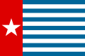 Image 5The Morning Star, flag of West Papua, was designed by the New Guinea Council in 1961. Its display is prohibited in some circumstances in Indonesia. (from History of Western New Guinea)
 Image 6Map of New Guinea, with place names as used in English in the 1940s (from New Guinea)

 Image 9Topographical map of New Guinea (from New Guinea)
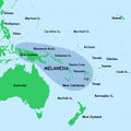
 Image 11A 1644 map of New Guinea and the surrounding area (from New Guinea)
 Image 12Papuans on the Lorentz River, photographed during the third South New Guinea expedition in 1912–13 (from New Guinea)
 Image 13Dutch expeditions in Netherlands New Guinea 1907–1915. (from History of Western New Guinea)
 Image 14Regions of Oceania: Australasia, Polynesia, Micronesia, and Melanesia. Australasia include the Australian landmass (including Tasmania), New Zealand, and New Guinea. (from History of Papua New Guinea)
 Image 15Political divisions of New Guinea (2006) (from New Guinea)
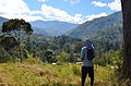 Image 16Highlands of Papua New Guinea (from New Guinea)
 Image 17Australian troops at Milne Bay, Papua.The Australian garrison was the first to inflict defeat on the Imperial Japanese Army during World War II at the Battle of Milne Bay of Aug–Sep 1942. (from History of Papua New Guinea)
- Image 19A typical map from the Golden Age of Netherlandish cartography. Australasia during the Golden Age of Dutch exploration and discovery (ca. 1590s–1720s): including Nova Guinea (New Guinea), Nova Hollandia (mainland Australia), Van Diemen's Land (Tasmania), and Nova Zeelandia (New Zealand). (from History of Papua New Guinea)
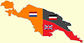 Image 22New Guinea from 1884 to 1919. The Netherlands controlled the western half of New Guinea, Germany the north-eastern part, and Britain the south-eastern part. (from New Guinea)
 Image 23Papuan lake dwellings with a lakatoi under sail, 1898 or before (from History of Papua New Guinea)

- Image 26Regions of Oceania: Australasia, Polynesia, Micronesia, and Melanesia. Physiographically, Australasia includes the Australian landmass (including Tasmania), New Zealand, and New Guinea (from New Guinea)

 Image 28Flag under German control of New Guinea. (from History of Papua New Guinea)
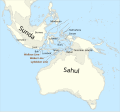 Image 30Map showing the combined landmass of Sahul formed during Pleistocene glacations (from New Guinea)
 Image 31Group of natives at Mairy Pass. Mainland of British New Guinea in 1885. (from New Guinea)

 Image 34New Guinea Volunteer Rifles with captured Japanese flag, 1942 (from History of Papua New Guinea)
- Image 35The continent of Sahul before the rising ocean sundered Australia and New Guinea after the last ice age (from New Guinea)
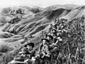 Image 36Australian soldiers resting in the Finisterre Ranges of New Guinea while en route to the front line (from New Guinea)
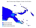 Image 37Papua New Guinea map of Köppen climate classification (from New Guinea)


.jpg)


.png)


.svg)


.jpg)


Related portals
In the news
- 27 May 2024 – 2024 Enga landslide
- Papua New Guinea asks for international help following the landslide in Enga Province three days ago, and reports that more than 2,000 people were buried alive and are now presumed deceased. (AP)
- 26 May 2024 – 2024 Enga landslide
- The International Organization for Migration estimates that more than 670 people were killed in the landslide in Enga Province, Papua New Guinea, on Friday. (AP)
- 24 May 2024 – 2024 Enga landslide
- Four people are confirmed killed and many others are presumed dead in a landslide in Enga Province, Papua New Guinea. (Papua New Guinea Post-Courier) (RNZ)
- 10 May 2024 – Palestine and the United Nations
- The United Nations General Assembly votes 143–9 with 25 abstentions to approve a resolution granting Palestine new rights and privileges, and to reconsider Palestine's request to become a UN member. The nine countries that opposed the resolution were Argentina, the Czech Republic, Hungary, Israel, Micronesia, Nauru, Palau, Papua New Guinea and the United States. (AP) (The National)
WikiProjects
General topics
Categories

Associated Wikimedia
The following Wikimedia Foundation sister projects provide more on this subject:
-
 Commons
Free media repository -
 Wikibooks
Free textbooks and manuals -
 Wikidata
Free knowledge base -
 Wikinews
Free-content news -
 Wikiquote
Collection of quotations -
 Wikisource
Free-content library -
 Wikiversity
Free learning tools -
 Wiktionary
Dictionary and thesaurus
External media


